Top Ten of Chinese Geography
China has the third largest land area in the world, reaching 9.6 million square kilometers. There are many magical geography and landforms on the vast land of China. From south to north, from west to east, the climate and environment are different, and various distinctive cultures have also been formed. In today’s post, I would like to introduce you to the top ten of Chinese geography.
1.China’s largest inland basin-Tarim Basin
The Tarim Basin is the largest inland basin in China. In the south of Xinjiang Uygur Autonomous Region. The north, west and south are surrounded by Tianshan Mountains, Pamir, Kunlun Mountains and Altun Mountains.
2.China’s largest grassland-Hulunbuir Prairie
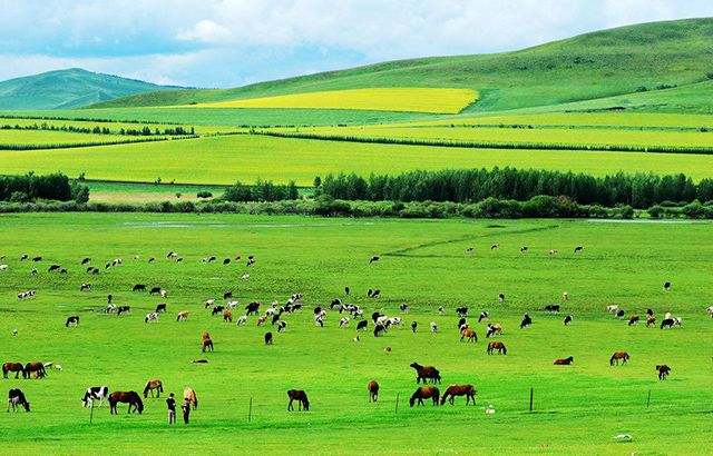
Hulunbuir Grassland is located in the northeast of Inner Mongolia Autonomous Region, west of Daxinganling. It is named after Hulun Lake and Beier Lake. The terrain is high in the east and low in the west, with an altitude between 650 and 700 meters, with a total area of about 100,000 square kilometers (149 million mu). It is a world-renowned natural pasture and one of the four largest grasslands in the world.
3.China’s largest plain-Northeast Plain
The Northeast Plain, or Songliao Plain and Guandong Plain, is one of the three largest plains in China and the largest plain in China. It is located in the northeast of China. It consists of the Sanjiang Plain, Songnen Plain, and Liaohe Plain. It spans Heilongjiang, Jilin, Liaoning and The four provinces of Inner Mongolia are located between the Daxinganling and Changbai Mountains, starting from the middle reaches of the Nenjiang River in the north and Liaodong Bay in the south. It is about 1,000 kilometers long from north to south, 400 kilometers wide from east to west, and covers an area of 350,000 square kilometers.
4.China’s largest plateau-Qinghai-Tibet Plateau
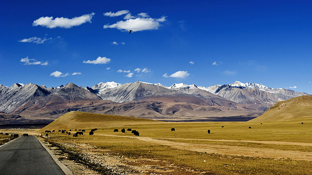
The Qinghai-Tibet Plateau is the largest plateau in China and the highest in the world. It is called the “Roof of the World” and “Third Pole”. It extends from the southern edge of the Himalayas in the south, to the northern edge of the Kunlun Mountains, Altun and Qilian Mountains in the north, and the Pamirs to the west. It is connected to the Karakoram Mountains in the east and northeast with the western section of the Qinling Mountains and the Loess Plateau. The Qinghai-Tibet Plateau is about 2,800 kilometers from east to west, and about 300 to 1,500 kilometers wide from north to south, with a total area of about 2.5 million square kilometers.
5.The highest mountain in China-the Himalayas
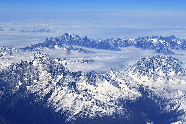
The Himalayas, located on the southern edge of the Qinghai-Tibet Plateau, are the highest mountains in the world, with more than 110 peaks reaching or exceeding 7,350 meters above sea level. It is the natural boundary mountain of the East Asian continent and the South Asian subcontinent. It is also the natural boundary between China and India, Nepal, Bhutan, Pakistan and other countries. Wafeng has a total length of 2450km and a width of 200-350km.
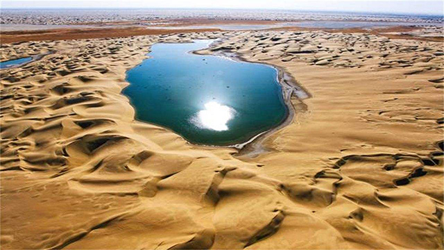
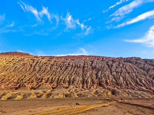
6.China’s largest desert-Taklimakan Desert
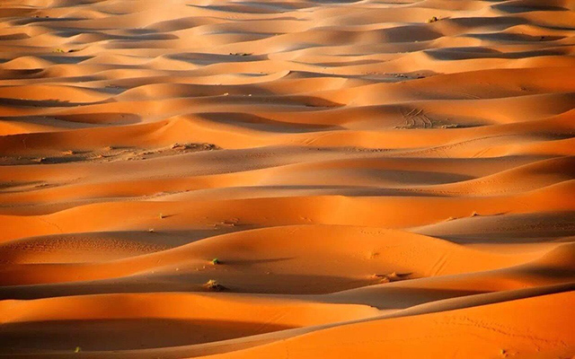
The Taklimakan Desert is located in the center of the Tarim Basin in southern Xinjiang. It is the largest desert in China, the tenth largest desert in the world, and the second largest mobile desert in the world. The entire desert is about 1,000 kilometers long from east to west, 400 kilometers wide from north to south, and covers an area of 330,000 square kilometers.
7.China’s longest canyon-the Three Gorges of the Yangtze River
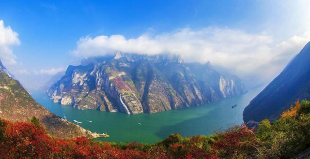
The Three Gorges of the Yangtze River, also known as the Xiajiang River or the Big Three Gorges, is located on the main stream of the Yangtze River in Chongqing, Enshi Prefecture, and Yichang City, China. It starts from Baidi City in Fengjie County, Chongqing City in the west, passes Enshi, and ends at Nanjin Pass in Yichang City, Hubei Province in the east. , 193 kilometers in length, composed of Qutang Gorge, Wu Gorge and Xiling Gorge
8.The highest basin in China-Qaidam Basin
The Qaidam Basin is one of the three major inland basins in China, and is a closed and huge intermountain fault basin. It is located in the northwestern part of Qinghai Province and the northeastern part of the Qinghai-Tibet Plateau, mainly in the Haixi Mongolian and Tibetan Autonomous Prefecture. The northwest reaches the Altun Mountains in the north; the Kunlun Mountains in the southwest; the Qilian Mountains in the northeast, covering an area of 257,768 square kilometers.
9.The lowest basin in China-Turpan Basin
The Turpan Basin is an intermountain basin on the southern slope of the eastern part of Tianshan Mountain, Xinjiang. The area is mainly Turpan City, covering 50140 square kilometers. “Turfan” means “low land” in Uyghur language.
10.China’s deepest canyon-Tiger Leaping Gorge
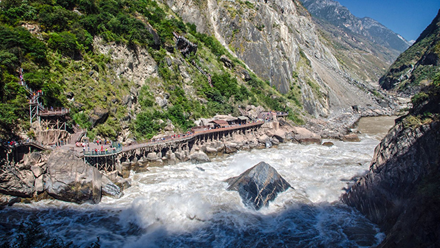
Tiger Leaping Gorge is located in Tiger Leaping Gorge Town, Shangri-La City, 96 kilometers away from Shangri-La City and 80 kilometers away from Lijiang City. The Jinsha River, which originated from the Gladan East Snow Mountain in Qinghai Province, has traveled thousands of miles here. It suddenly encountered the obstacles of the Yulong and Haba snow mountains. The originally calm and peaceful river suddenly became furious. Tiger Leaping Gorge is the largest canyon of the Yangtze River in thousands of miles. Between Haba and Jade Dragon Snow Mountain, they are named after the legend of a fierce tiger leaping over the river. The roaring water and rocks below 3900 meters and a short drop of 216 meters are well-known in the world for their high mountains and deep valleys.

